There’s an undeniable human longing to climb the nearest hill, or ascend the tallest building, simply to see as far as we can see. Here are my favorite U.S. high points — each one easily accessible by car, stairs, or elevator.
Maunakea
Hawaii (13,802 feet, free)
You can’t just drive to the top of what is, by some measures, the world’s tallest mountain. Well, it’s possible, but not advised: Those venturing to the 13,803-foot-high summit of Hawaii’s Maunakea are required to spend a half-hour or so at the visitors’ center — a mere 9,199 feet up — to give their lungs and brains times to adapt to the reality that people are, quite simply, not built to live this high above sea level.
That’s where I find myself with my son Nick, impatiently walking among the modest exhibits primarily designed, it appears, to occupy our attention while our bodies adapt to the elevation.
After 45 minutes (just to be safe), we are back in our vehicle and ascending. Beyond the visitors’ center, the Maunakea road is unpaved. And steep. So steep, in fact, that the gravel trail occasionally disappears below the hood, and I navigate mainly by looking out the driver’s window to make sure I don’t drift too far to the left. This is why only 4-wheel-drive vehicles are permitted beyond the visitors’ center — and why almost no rental companies on the Big Island are willing to let customers take their vehicles up here.
Eventually, we nose our way onto the mountain’s relatively flat summit. In a small parking lot, we spot a tour company’s 4×4 van — the safest and, I’m now thinking, preferable way to get up here.
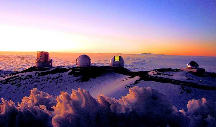
Scattered around the summit, like enormous white mushrooms, is the world’s largest array of telescopes, operated by universities and scientific agencies from around the world. And in irregular patches at their feet, wildly incongruous so near Earth’s equator, white area rugs of snow splotch the landscape. Drifting across a volcanic depression, their voices muted by the thin air, a couple of teenagers squeal in delight as they slid down a snowy incline atop a large sheet of scavenged cardboard box.
In this realm above a thin layer of clouds, twilight is when Maunakea comes to life. The telescope domes slowly spin into position. Their massive skyward doors slide open. And to the east, the shadow of Maunakea begins its nightly march across the Pacific Ocean.
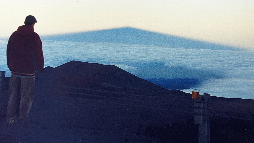
Nick and I stand at the mountain’s highest spot, accompanied by a clutch of fellow witnesses.
The world is blessed with any number of beautiful sunset spots, but few of them so thoroughly reward observers for turning their backs to the dipping sun. Before our eyes, growing like a hulking creature of darkness, the profile of Maunakea looks less like a mountain than a pyramid, its pointed tip reaching all the way to the horizon, nearly 140 miles away.
The air is perfectly still, yet there’s an undeniable sense of motion: The Earth’s rotation; the sun’s departure; the shadow’s race to infinity. Like everyone else, Nick and I stand in silence; not that we have nothing to say, only that words would never suffice.
Too soon, the show is over. We civilians must evacuate the mountaintop before darkness, lest out headlights blind the assembled astronomers.
But it’s not all bad: Ironically, despite our elevation, were we to stick around until pitch darkness we would not see the stars nearly as well as we will when we stop halfway down the slope, at the visitors’ center. The reason: Our eyes need a lot of oxygen to register the glories of starlight, and there’s just not enough of it up this high (with their electronic eyes, telescopes face no such limitation).
It’s worth the stop. The sky above Maunakea is aflame with stars in a kaleidoscope of colors: white, red, and blue. To the naked eye, they seem to swirl, like in a Van Gogh painting. To our right and above, the bowl of celestial sparklers is interrupted by the stark blackness of Maunakea’s summit.
“Excuse me,” a young woman’s voice pipes up in the darkness. “Are you driving down?”
It’s a strange question, because of course from here there’s nowhere to go but down. It turns out she’s one of a pair of Israeli students, spending a year seeing the world. They bummed a ride up here and have lost track of their driver.
They sit in the back seat, chatting incessantly about their adventures. We know they’re just trying to be friendly, but Nick and I wordlessly wish they would tamp it down a bit.
There’s a reason Hawaii’s indigenous people hold this mountain as sacred. When you leave a sanctuary, respectful silence is really the only way to go.
Griffith Observatory
Los Angeles (1,134 feet, free)
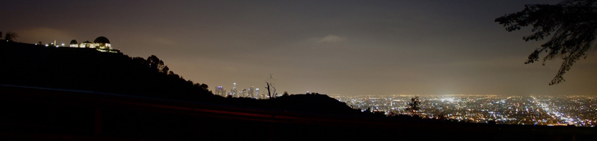
When James Dean stood up here with Natalie Wood in Rebel Without a Cause, director Nicholas Ray imagined them as star-crossed teen lovers hovering between the tranquil stars of the night sky and the turbulent galaxy of nighttime Los Angeles, swirling below them.
Surprisingly, the urban nightscape that unrolls like a luminescent Persian rug at the foot of Mount Hollywood has changed little in the 70 years since Rebel. The grid of streets, laid out in the early 1900s, still imposes its will on the city below.
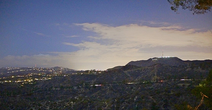
But after dozens of visits to this iconic spot, I’ve learned not to settle for just the panoramic city view. A short walk along the observatory parking lot delivers a sweeping look at the Hollywood Hills, and the iconic sign that has beckoned Movieland hopefuls for a century.
If you’re new to LA, you might think you’ve made a wrong turn as you drive up to the observatory. The winding road takes you through the Los Feliz neighborhood (What other city in the world would have a community with a name that translates to “The Happy?”). Stick with it, but remember to come back out this way, rather than try to drive all the way through the park; I learned the hard way that the gate at the other end of Western Canyon Road is often locked after dark.
Philadelphia City Hall
Pennsylvania (500 feet, $15)
phlvisitorcenter.com/CityHallTowerTour
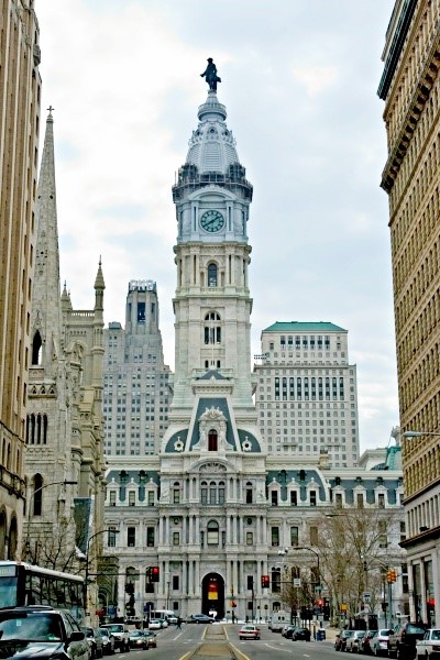
There was once a gentlemen’s agreement that no Philly tower would top the brim of William Penn’s hat on the statue that crowns this ornate granite layer cake of a building, once the tallest building in the world and still the tallest city hall.
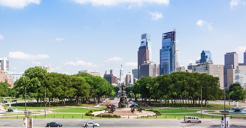
Spoilsports broke the rule in 1987, but the view from the feet of Penn’s 27-ton statue is still the best in town: The vista down Benjamin Franklin Parkway toward the Philadelphia Museum of Art is worthy of the great cities of Europe.
Upon your return to street level, don’t forget to turn around and look up at the tower. It took 25 years to build City Hall after the cornerstone was laid in 1874, and it would seem that entire time was spent carving the 250-plus figures that cling to the tower’s exterior. A nice pair of binoculars will reveal that even figures hundreds of feet up are lavished with detail, including eyeballs and even fingernails.
Clingmans Dome Observation Tower
North Carolina/Tennessee border (6,643 feet, free with admission to Great Smoky Mountains National Park)
nps.gov/grsm/planyourvisit/clingmansdome.htm
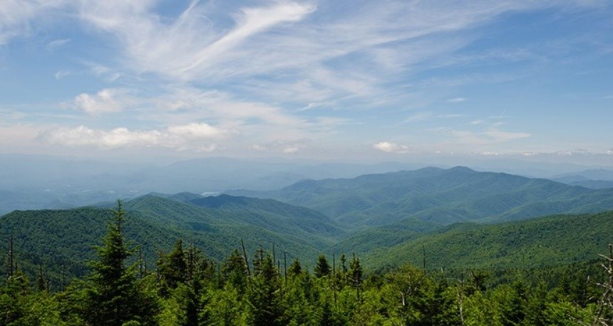
East of the Mississippi, there are only two spots higher than Clingmans Dome: —Mounts Mitchell and Craig in North Carolina’s Black Mountains — and neither has a nifty observation tower that reaches above treetop level, offering a 100-mile view, including seven states, on clear days. The half-mile walk from the parking lot is steep, but worth it.
Before you pile everyone in the car for a climb to the Dome, though, do check the weather: It’s not unusual for temperatures up there to range 20 degrees cooler than down in the valleys.
Old Post Office Bell Tower
Washington, D.C. (315 feet, free)
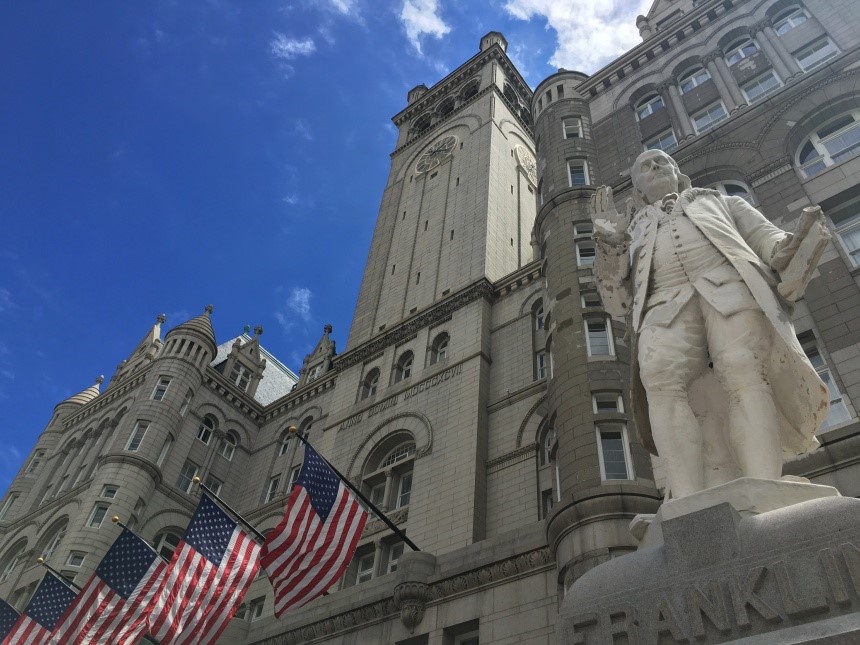
This century-old landmark on Pennsylvania Avenue came very close to being demolished back in the 1960s, but it got a reprieve thanks to the nascent historic preservation movement.
Lucky us: That saved one of D.C.’s most distinctive buildings, along with one of its most unusual up-on-high views. Most of the former D.C. post office is now a plush hotel, but the developers, who leased it from the government, have not been allowed to touch the bell tower, which is run by the National Park Service.
It’s not easy to find the tower entrance — all the way out back, on the opposite side from Pennsylvania Avenue — but after a park ranger waves you through you’ll be whisked by elevator to the colonnade up top.
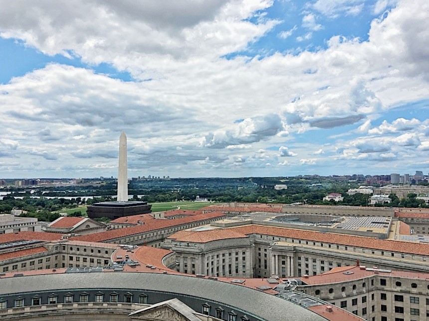
There are three reasons why the Old Post Office affords a better view than the nearby Washington Monument: 1. The lines are longer at the Washington Monument, 2. The windows are tiny atop the Washington Monument, and 3. Most importantly, you can’t see the Washington Monument from inside the Washington Monument!
Pike’s Peak
Colorado (14,110 feet, $50 for a carload)
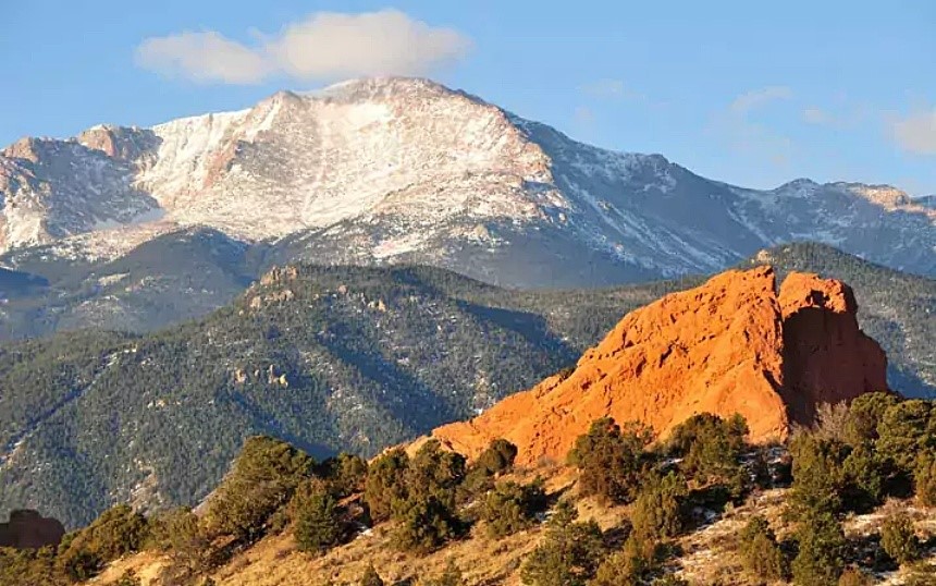
Worldwide, only Japan’s Mount Fuji attracts more summit-seekers than the mountain that inspired Katharine Lee Bates to write “America the Beautiful.” The 19-mile, one-way drive takes about an hour-and-a-half — that’s if you don’t stop to admire the valleys, mountain views, and occasional bear along the way. And you will, so don’t plan on zipping up and back in less than four hours (how could you resist pull-outs with names like Crystal Reservoir or Devil’s Playground?). But plan ahead: Reservations are required May through September.
The faint-of-heart can choose to take Pike’s Peak’s historic cog railway ($58.50 per person), which has just celebrated its 130th year in operation.
Either way, with the Rockies’ purple mountain majesty to the west and the fruited plain to the east, you’ll be inspired, too.
Bunker Hill Monument
Boston (221 feet, free)
nps.gov/bost/learn/historyculture/bhm
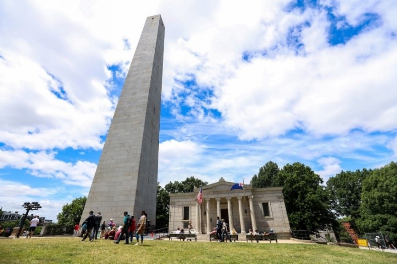
The elevation isn’t anything to write home about, but if you get high on U.S. history, it’s hard to beat this obelisk atop 65-foot Breed’s Hill (the actual site of the famous 1775 skirmish between Bostonians and Brits).
Built within living memory of many veterans of the American Revolution, its cornerstone was laid by the Marquis de Lafayette himself.
After a 294-step climb, you’ll find it kind of cramped in the observation chamber. But as you move from each of the four windows to the next, with all of Boston and its bay spread at your feet, you can almost smell the gunpowder from the British muskets, and hear someone shout from somewhere in the swirling smoke, “Don’t fire until you see the whites of their eyes!
Become a Saturday Evening Post member and enjoy unlimited access. Subscribe now

