Mount St. Helens: The Day the Earth Caught Fire
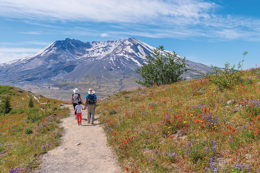
The predawn forest is dark and cold, and quiet except for the crunch of our footsteps over pine needles. Clouds of my breath reflect the light from my headlamp. Gradually, as we reach the edge of the tree line, a sharp, boulder-strewn shoulder appears, forming a diagonal through low clouds.
We’re climbing in earnest now, pulling ourselves over a maze of rocks stretching 4,500 vertical feet. The alternative — trudging up the adjacent crevasse-cracked snowfields, which fall thousands of feet toward the ground at a nearly 45-degree angle — seems horrifyingly exposed. As we inch skyward, the rising sun warms the earth and the vast, black landscape we’re crawling over.
My friend Kelsey and I had peeled ourselves from our sleeping bags in the small hours, fueled up on instant coffee and protein bars, and aimed our headlamps toward the summit of North America’s most notorious volcano, Mount St. Helens. Our 10-mile climb up the southern slope and back to our camp will take us nearly 10 hours.
“The lesson we’re taking from Mount St. Helens is that we need to be working on other volcanoes … so when they wake up, we won’t be nearly as behind the eight ball as those folks were back in 1980.”
Though physically demanding, climbing Mount St. Helens requires no advanced mountaineering equipment or knowledge, and hardy hikers who have taken adequate safety precautions and secured the necessary permits routinely claim a spot on the summit.
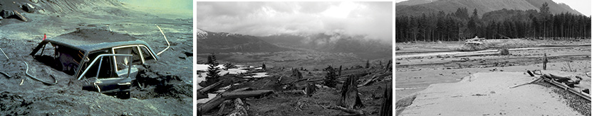
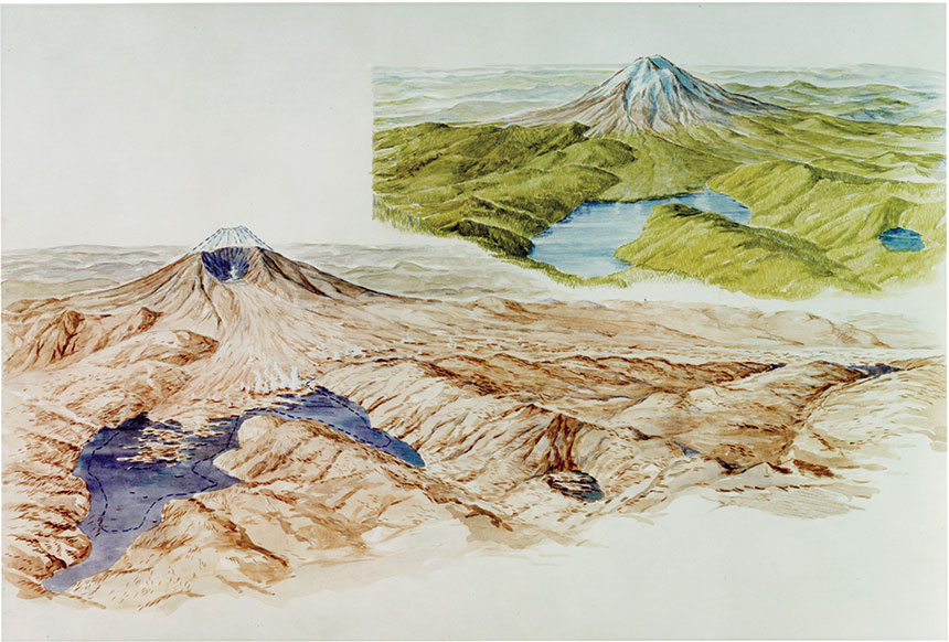
The landscape I’m scaling looked a lot different 40 years ago. In the spring of 1980, rising magma deformed the northern face of Mount St. Helens’ 9,677-foot, symmetrical cone. Things came to a head on the morning of May 18, when the bulging northern slope failed. “The whole top of the mountain slid away in the largest landslide in recorded history, and it filled this valley, as far as 12 miles away, to an average depth of 120 feet,” says Charlie Crisafulli, a U.S. Forest Service research ecologist who began studying Mount St. Helens just after the eruption.
Crisafulli likens that landslide to removing the lid of a pressure cooker; immense pressure had been building inside the mountain, which the landslide released, sending an incredibly powerful blast of lava blocks, snow, ice, and rocks outward at hundreds of miles per hour. “It leveled the trees like they were matchsticks,” Crisafulli says. “Then, beyond the extent of the toppled forest, the heat associated with the blast was enough to sear the needles of the conifer trees, killing them, but not leveling them, so you have a standing dead forest.” The devastation didn’t stop there. “It melted glaciers and ice, creating these slurries of cement-like consistency down the side of a mountain, called mudflows.”
Later came pyroclastic flows — currents of super-heated gas and rock that move at speeds of up to 450 miles per hour — laying waste to anything they touch. And rising from the newly formed crater was that volcanic signature — an 80,000-foot-tall mushroom cloud that scattered visible ash across 11 states.
All told, 57 people died in Washington State’s most infamous natural disaster — the most destructive volcanic eruption in our nation’s recorded history — that also destroyed 47 bridges, 15 miles of railways, 185 miles of roads, and some 250 homes. In the 20th century, it’s preceded only by the 1917 eruption of Lassen Peak in California. Millions of Americans alive today may remember opening their newspapers to read about Mount St. Helens’ eruption or learning about it on the evening news. Some may even recall brushing ash off their car windshields.
As an ecologist, Crisafulli’s job is to observe the widespread environmental changes taking place post-eruption. Closer to ground zero, scientists are offered a rare opportunity to study environmental renewal from “a clean slate,” as he calls it, where every living thing — from massive, ancient old-growth trees to the plants and animals they sheltered — was destroyed. Mount St. Helens offers an unparalleled opportunity, he says. “Scientists in the U.S. didn’t have experience with explosive volcanoes, so we really didn’t have a lot of understanding of what to anticipate and how to even approach our work necessarily.”
Because Mount St. Helens is so close to large population centers with major research institutes and sits on public — not private — lands, scientists were on the ground very quickly before and after the eruption, as opposed to months or years later when eruptions happen in more remote places. “The opportunity was not squandered. Within the first couple of years, there were over 200 studies established and included thousands of researchers,” Crisafulli says. “They looked at everything from molecules to the entire ecosystem. This highly skilled cadre of scientists entered the scene and collaborated to develop a remarkable long-term dataset. For 40 years, people have been studying the volcano and really trying to understand what were the initial ecological responses. How did the longer-term processes of succession and assembly of biological communities happen.”
Crisafulli and his colleagues have taken their findings to sites of other volcanic eruptions all over the globe. Their findings inform understandings of how ecosystems recover from more than just volcanic activity — they can be applied to environmental renewal after activities like clear-cut logging, mountaintop removal mining, and dam removal. “Lessons from St. Helens have helped inform how succession might occur there and how managers might go about using those lessons to get other ravaged lands back into a productive state.”
Lacking a geologist’s trained eye, I momentarily forget I’m traipsing along the back of the geophysical equivalent of a serial killer. But that fact comes into shocking focus as we ring equipment: a beefy tripod next to a large, metal box that I later learn is a GPS station, installed to measure ground surface movement, or deformation — indications that the mountain could someday wake up again. “That’s there to tell us if the surface of the volcano is changing shape at all,” says Seth Moran, the scientist-in-charge of the USGS Cascades Volcano Observatory, which is tasked with researching, monitoring, and community outreach around the threats posed by the Northwest’s most famous volcano. The agency was created in the months after May 1980 to better prepare for a future eruption in Idaho, Oregon, or Washington.
The station I pass is one of two dozen scattered around Mount St. Helens, each one keeping an eye on deformations created by surging magma within the mountain. It’s all part of an early warning system designed to predict what might happen here and to better alert people living in the shadow of the volcano.
(USGS)
Before Mount St. Helens rumbled to life starting in March 1980, there was very little monitoring of the volcano — in fact, the mountain had just one monitoring station when a series of earthquakes alerted scientists that something was going on that spring. “There was a tremendous scrambling and marshaling of resources, and within a couple of weeks a pretty good-sized network was installed and operational. And that was with some luck,” Moran says, explaining that clear weather allowed good access to the mountain, and “there happened to be some equipment lying around.”
Moran adds, “It was also pretty dangerous, and people that were working on the volcano were taking a lot of risks in doing that. But there was a lot of baseline understanding of the volcano that was missed because there was not anything on the volcano really before then.”
Today’s technology, research funding, and warning procedures represent significant improvements and advancements over what was in place 40 years ago. The findings from 1980 are being applied to volcanic systems around the world, many of which pose greater dangers to surrounding communities than St. Helens ever did. For example, Moran says six volcanoes in the Cascade Range of the American Northwest are inadequately monitored today. He’s pushing for more monitoring on each of them, especially on Oregon’s Mount Hood, which, while possessing less eruptive potential than Mount St. Helens, sits closer to major population centers, posing a potentially more deadly threat. In fact, half of America’s 10 most dangerous volcanoes sit within the Cascade Range.
On Mount Hood, laws governing land use, which protect federal wilderness areas from the building of additional structures, have created regulations that prevent scientists from installing adequate monitoring stations. It’s a battle that pits scientists against environmentalists in an ongoing tug-of-war, with little indication as to how much time we have before an eruption. “The lesson we’re taking from Mount St. Helens is that we need to be working on other volcanoes to get them at least to a basic level so when they wake up, we won’t be nearly as behind the eight ball as those folks were back in 1980,” Moran says.
Our climb finally takes us beyond the boulder field, and soon we’re staring straight up toward the summit, where small puffs of steam catch a cool breeze. Improbably, in this alpine desert of barren rock, a hummingbird zips past overhead, making its way up the mountain. In the distance, the clouds cradle a view of Mount Hood’s pyramid to the south and Mount Adams to the east, two more Northwest members of the Pacific Ring of Fire, a necklace of active volcanoes arching from New Zealand to Japan to Washington State to South America.
The last 1,000 feet of the climb is an exercise in patience as we walk on ash the consistency of kitty litter. Every tedious step up is offset by a slight sinking back down, and I find I make better progress if I trudge upward without stopping for a break. I keep my eyes trained on the summit ridge.
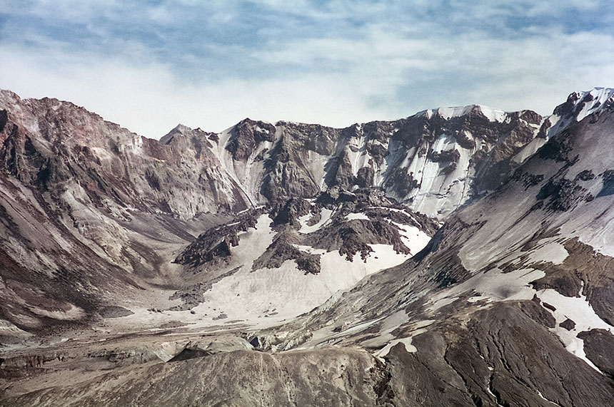
After a final push, we’re standing at the 8,300-foot summit — no longer a smooth cone, but a jagged, semicircular rift hugged by a cornice of dirty snow. Steam, created when melting snow seeps through cracks in the rock and meets hot magma, plumes from multiple spots inside the crater. The earth here, with the planet’s great tectonic forces exposed, feels very much alive — and unsettled, a reminder that earth is governed by fire, and land is born of violence. It’s no surprise this rowdy hunk of geology earned the name Loowitlatkla, or “Lady of Fire,” from the Puyallup tribes and Lavelatla, “smoking mountain,” from the Cowlitz tribes.
Steam, created when melting snow seeps through cracks in the rock and meets hot magma, plumes from multiple spots inside the crater.
Careful not to get too close to the brittle edge, I peer into the crater incised by the 1980 blast. Within this breach sits a chaotic scene of rock and ice falls, steam, rivers of snowmelt, and hot springs. At the crater’s center sits a new dome, signaling the mountain’s regrowth as magma continues forcing its way into the mountain’s core. A newborn glacier — Crater Glacier — hides behind the south side of the dome.
This chunk of ice is significant for a few reasons: It sits at a relatively low elevation, and it’s the youngest on the continent. And in a time when climate change means most talks of glaciers are accompanied by the word receding, Crater Glacier is actually growing.
Looking north, the horseshoe-shaped crater opens toward a vast fan of scarred earth, called the Pumice Plain, with the blue waters of Spirit Lake standing out against the brown, bombed-out landscape. Scores of massive logs, once part of a magnificent old-growth forest, hug one shoreline — another reminder of the volcano’s power. Mount Rainier, the state’s tallest peak and the most glaciated mountain in the Lower 48, rises above the rumpled landscape.
It’s hard to imagine that St. Helens once bore a cone even more symmetrical than Rainier’s, and was similarly draped in massive glaciers. Rainier, too, is an active volcano, one more in a chain running from southern British Columbia to Northern California. Another sleeping giant, hovering over the Pacific Northwest, waiting its turn to unleash the most powerful natural forces on the planet.
Megan Hill contributes to AFAR, Sierra, Hemispheres, Global Traveler, among other publications. She wrote “How a Dying River Was Brought Roaring Back to Life” (March/April) about dam removal on the Elwha River in the Pacific Northwest.
This article is featured in the May/June 2020 issue of The Saturday Evening Post. Subscribe to the magazine for more art, inspiring stories, fiction, humor, and features from our archives.
Featured image: Science History Images/Alamy Stock Photo