All photos courtesy of Bill Newcott unless otherwise noted
Infinite deserts, snow-capped mountains, plunging canyons, and the World’s Largest Pistachio are just the beginning of one of the world’s great drives: A week-to-10-day loop through Arizona and New Mexico, never traveling more than a couple hundred miles a day, covering some of the most famous (and surprisingly obscure) sights in America’s Southwest.
You land in Phoenix, then get the heck out of there, setting your GPS for each new destination. And do yourself a favor: Set your preferences to “Avoid Highways.”
Silver City, New Mexico

Just across the Continental Divide is this little town where more than 30 art galleries and artists’ studios line the old street. Out on route 180, in Gila National Forest, find the parking area for the Dragonfly Trail, a relatively easy 3-mile trek that leads across fields and up rocky inclines to a rocky dotted with petroglyphs. The most famous one, of a whimsical dragonfly, is estimated to be 1,000 years old. The trail gets hot in the summer and cold in the winter; bring water to drink.
City of Rocks, New Mexico

On virtually no-one’s tourist map is this state park, crowded with towering, teetering rock formations. Enter the rock field between any two sentinels and it’s easy to get lost in a stony labyrinth. The enormous, weirdly shaped boulders, standing in a wide flat basin, look like they were dropped out of the sky — and in a sense, that’s exactly what happened: Thirty-five million years ago, a volcano some 30 miles away blew its top, laying down a thick blanket of ash that hardened into stone. Eons of erosion left these natural sculptures that, without even squinting, resemble an army of stocky human figures.
White Sands National Park, New Mexico

As you drive east on I-10 toward Alamogordo, there’s little evidence that just beyond that low-lying hill to your left lies one of North America’s most dramatic desertscapes. Make the turn into White Sands National Park, though, and almost immediately you’re confronted with a scene straight out of Lawrence of Arabia: 275 square miles of impossibly white, sugary sand. This gypsum dune field — blown here over the eons from mountains and dry lake beds to the west — invites the adventurous traveler to scale its 60-foot-high dunes, which offer vistas of endless, undulating sand that seem to stretch all the way to the nearby mountains. As you clamber atop the dunes, know you’re in good company: North America’s oldest known fossilized human footprints were found here.
Alamogordo, New Mexico

Just beyond White Sands lies this town at the foot of the Sacramento Mountains, the closest bit of civilization to Trinity, the site of the first nuclear bomb test in 1945. Travelers tend to drive right through Alamogordo, but there’s more than one good reason to linger. For one thing, the town is home to the World’s Largest Pistachio Nut — visible from the highway. At three stories high, the concrete nut lures tourists to McGinn’s PistachioLand, where you can board a tram for a tour of the McGinn family’s sprawling pistachio farm, or just drop into the gift shop for pistachio fudge, pistachio brittle, or a bottle of Pistachio Delight white zinfandel. Beyond the Big P, Alamogordo also offers the Shroud Exhibit and Museum — home to a full-size replica of the Shroud of Turin — and the New Mexico Museum of Space History, where you can see a real moon rock and walk through the International Space Hall of Fame. The museum is also a gathering point for semi-annual tours of the nuclear blast site at Trinity.
Sandia Crest, New Mexico

Heading north to Santa Fe, you’ll be tempted to zip up I-25, but don’t do it. Instead, veer off to Route 14, also known as the Turquoise Trail, named for the rich mineral deposits mined in the area for over 1,000 years. Just a few miles into the winding, 52-mile scenic byway is the entrance to Sandia Crest, a 10,679-foot-high mountain that overlooks Albuquerque and the desert beyond. Halfway to Santa Fe you’ll coast into Madrid (pronounced MAD-rid), an old coal mining town that in the 1980s became a refuge for artists escaping the rising cost of living in San Francisco. Visit the shops (and pick up some locally crafted turquoise jewelry), but don’t leave until you’ve had a drink at Madrid’s one and only watering hole, The Mine Shaft.
Santa Fe, New Mexico

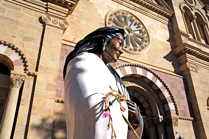
The oldest and highest state capitol in the United States is also the earliest existing European settlement west of the Mississippi, dating back to 1610, barely 120 years after Columbus landed. That’s why Santa Fe’s adobe-lined streets echo with reminders of its Indigenous, Spanish, and American frontier influences. It’s also one of America’s artiest cities, with one-tenth of its workforce employed in the arts (there are more writers and authors here per capita than any other U.S. city). As you wander the city, linger for a moment outside The Cathedral Basilica of St. Francis of Assisi, where you’ll find a pensive statue of Kateri Tekakwitha, the first Native American canonized a saint by the Roman Catholic Church. And if you come in the fall, head up to the mountains to witness the gold-hued miracle of the Aspen Trail.
Petrified Forest National Park, Arizona

As the name implies, the main road inside this remote national park leads you to the graveyard of an ancient forest, its fallen tree trunks turned to blood-red stone after eons of absorbing minerals from the soil. Even more dramatic, though, are the stratified hills and cliffs that line the road; red and tan layer cakes of rock-hard sediment. Arrive near dusk, just before the park closes, and watch the colors of the sunset seem to set the landscape on fire.
Meteor Crater, Arizona

As you drive the five-mile road south from I-40, following the signs to Meteor Crater, you could be forgiven for wondering if you’ve fallen for another Roadside Attraction Boondoggle. Then, as you approach the 150-foot-high hill dead ahead, you begin to realize that’s no hill at all, but a towering rim that disappears in a wide arc on either side. And once you’re atop it, the horrifying truth about Meteor Crater becomes clear: 50,000 years ago, when an iron rock the size of an apartment building plowed into this spot at 29,000 miles per hour, you would have wanted to be anyplace but here. A museum overlooking the ¾-mile-wide, 560-foot-deep hole contains a fragment of the meteor and a fascinating lesson in cataclysmic natural history.
Sunset Crater Volcano National Monument, Arizona

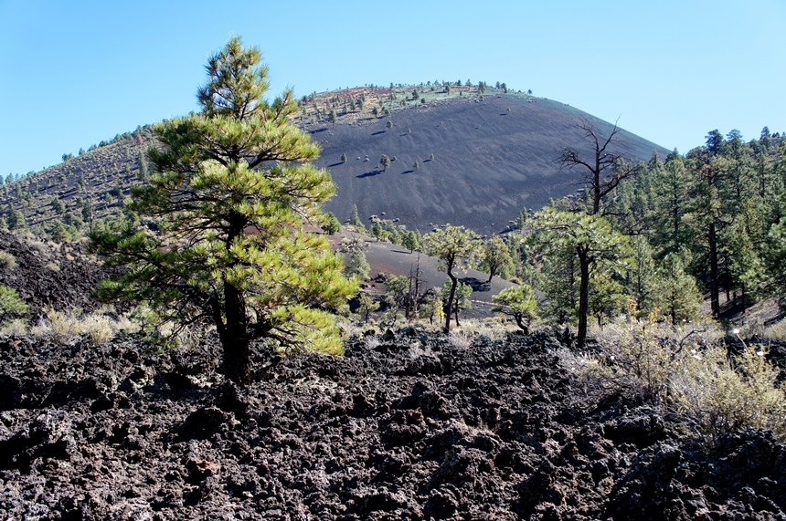
At first glance, the lava-covered landscape in the shadow of an ancient volcanic cinder cone seems wildly inhospitable to life. But even a casual stroll along the park’s mile-long nature trail reveals plants and animals reclaiming an area that remains devastated by a volcanic eruption that took place nearly 1,000 years ago. Pine trees and wildflowers push stubbornly upward between the rocks. Besides insects, spiders, lizards, and rodents, bats flit in and out of hidden lava tubes. And every once in a while, you’ll spot a rare squirrel, cottontail, or coyote wandering in from the surrounding pine forests.
The Grand Canyon, Arizona

You’ve heard of it. We’re not including The Big Ditch in this itinerary, because it deserves a trip all its own. But if you must, you’ll find the South Rim about 80 miles north of Flagstaff.
Oak Creek Canyon, Arizona

Stop in Flagstaff to visit the Lowell Observatory and see the telescope that discovered the once-and-future-planet Pluto. But as you turn south toward Sedona, resist the temptation to head down I-17. Instead, take the scenic route along this road that passes through towering canyon walls, and stop at Slide Rock State Park to, as the name implies, careen down the natural flume of Oak Creek.
Sedona, Arizona

Are there really mystical energy vortexes here that promote health and inner peace? Perhaps, but there’s no doubt about the astonishing supply of easy-to-reach paths that take you to some of the most beautiful vistas in the country (two easy trails: Teacup and Courthouse, both accessible from parking lots and stunningly stark). Stop at the Chapel of the Holy Cross, carved out of a mesa side, and marvel as, when the sun sets, the very air seems to turn a deep red as waves of bats carve fleeting sculptures in the sky.
Montezuma’s Castle National Monument, Arizona

Montezuma never came here, and it’s not a castle, either, but these ancient cliff dwellings along a rushing stream are a peek at what life was like before Europeans set foot in the Southwest.
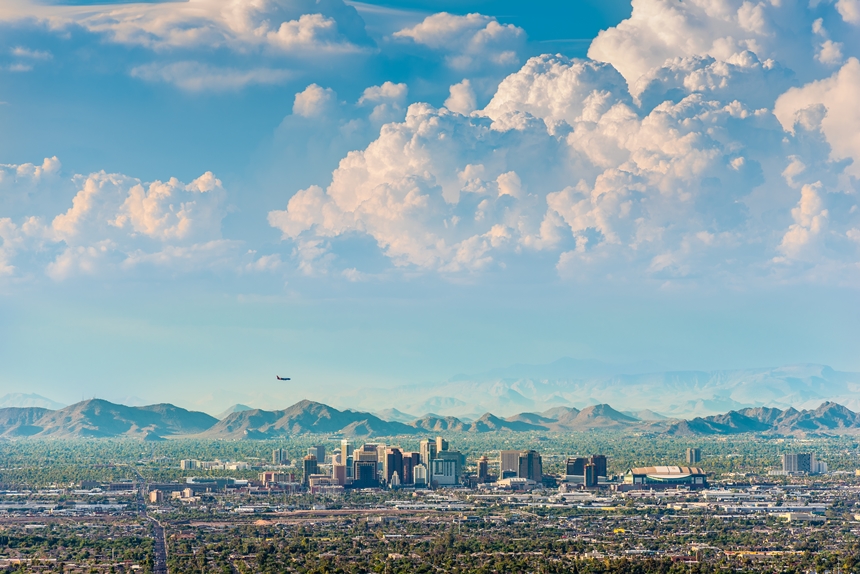
Phoenix, Arizona

It’s probably best to head straight for the airport and go home. Your libraries —both cerebral and photo — are by now beyond full.
Become a Saturday Evening Post member and enjoy unlimited access. Subscribe now


Comments
The land of the dancing sun is not ‘baron’ if you dare look beyond the endless blue horizons and 12 thousand foot peaks and into those red cliffs that protect the cradle of human history in North America. This is a mystical journey where the writings of ancient peoples may be found carved in rocks, discovered on your next hike.
You missed a wonderful National Park in Carlsbad Caverns it is really fascinating
Great want to do it
Just 4 days ago we finished a tour of the Big 5 Southwest national Parks. Had a great time, really enjoyed the sites even if the drive was boring and visually unappealing.
But I’m very grateful we didn’t use this itinerary. This is lifeless and unappealing.
Even as pretty as Bryce, Zion, Monument Valley, Grand Canyon, Canyonlands, Mesa Verde, Capital Reef and everything else we visited were, we were very happy to come back home to Maui! Much prefer the lush tropics to the stark mostly baron red desert.