Pity the motorists of a century ago. Automobiles in the 1900s were slow, stiff, and undependable. Gas stations were scarce. The roads, where they could be found, were in wretched shape. (In 1910, there were only 10 miles of paved highway in the U.S.) Traveling these rocky, rutted paths caused car engines to overheat and tires to blow out with a disheartening regularity.
As if this wasn’t enough discouragement, there was the challenge of navigating. Road signs were rare and often incorrect. Travelers were frequently reduced to driving from one roadside stranger to the next, gathering a few miles of directions at a time. The earliest road maps by Rand McNally were printed only after 1904.

Yet a high-tech alternative appeared in 1909: a real-time, on-board directional guide called the Jones Live Map. It was invented by J. W. Jones, who had also introduced the Jones Speedometer, the Jones Disc Phonograph Record, and the Jones Yobel —“the gentlemen’s automobile horn.”
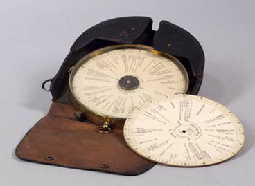
The idea was revolutionary. The Live Map was a small turntable device with a cable that attached to an automobile’s odometer. Before making their journeys, drivers would purchase paper discs with the route to their destination prescribed by The Touring Club of America.
At the beginning of the journey, the driver would place his journey’s disc to the Live Map’s turntable so that the journey’s starting point lined up with an arrow indicator on the glass cover. As the car began rolling, the turning odometer cable caused the map to rotate. The arrow would point to the driver’s changing position in the journey.
Each disc had up to 100 miles of travel details around its perimeter. If the journey was longer than 100 miles, the driver would replace the first disc with a second, or third part.
A Saturday Evening Post advertisement for the device described it as
the phonograph of the road. It has disc records covering the roads of the entire world. You insert the record of the trip you want to make. The Live-Map “plays” it. Not out loud, but with a pointer that always points the way—that tells you where you are now and what to do about it.
To have it with you is like having in your car a man who knows every road, every corner, every crossing, every landmark, every puzzling fork and crossroad in the entire world.
A 1910 booklet, “The Jones Live Map – What Happens Without It” brags that the Jones Live Map would save the driver from the Evil Genius of the Roads, the stranger who always gave incorrect directions. It was superior to route books, which were hard to follow and led drivers into unlisted trolley and railroad crossings. And it was more convenient than the large, clumsy, origamical maps that could never be refolded and were always tearing in the wind.

Jones Manufacturing was offering over 500 routes by 1919. The routes span the entire country from New York to Los Angeles, and included notification of speed laws where they existed.
However, the problem with this first GPS was the same that plagues such systems today. Roadways are in a state of continual change. Every time the Live Map offered printed directions like “take a right at the fork by the flag pole,” it was fighting a losing battle. Landmarks like flag poles could be removed at any time. The map discs might be corrected and reprinted, but a driver’s old discs, which relied on missing landmarks, could be close to useless.
By the 1920s, there was an abundance of road maps for much of the country. States and counties had begun identifying roadways with standardized signs along the roadside. Jones Live Map ceased production.
The next attempt to provide instantaneous driving directions didn’t appear until 1994, when the Department of Defense launched its Global Positioning System, which could locate the signal from a GPS device through a network of 24 satellites. The system was authorized for civilian use in 1996.
It quickly became popular with women drivers, but it proved just as welcome to men who felt that consulting their Garmin or TomTom wasn’t really asking for directions.
Postscript
The need for reliable navigation hasn’t changed in over a century, but the etiquette of the road certainly has. In 1909, the Jones manufacturing company sold its Yobel horn for its good manners, as this ad copy shows:
There is a vast difference between an automobile signal which says, “I’m coming,” and one which says “Get out of here.”
One is a gentleman’s request for his fair share of the road; the other is an insulting, abusive command to get into the ditch.
At the sound of one signal, a man turns out with quick civility; at the sound of the other, he unwillingly sulks aside.
Mr. J. W. Jones wanted a signal which would get the road without getting everybody mad, so he invented the New Jones Electric Yobel.
It is a signal that carries as far as any of the shrieking horns, but gives no offense. It sounds one harmonious, penetrating note. It is not the loud, coarse, vulgar blast of the rowdy. It is the signal of a gentleman’s car.
Become a Saturday Evening Post member and enjoy unlimited access. Subscribe now

Comments
In 1984 the German Steven Lobbezoo invented also a navigation system.
Source: http://en.wikipedia.org/wiki/Automotive_navigation_system
Acura actually had a navigation system as an option in its 1990 Legend model that used a gyroscope and the odometer to figure out where it was – not GPS.
And a gentleman’s car I shall drive.
I do remember way back when
Hubby and I went autoing.
‘Twas early spring of nineteen ten,
Hubby was showing off his thing –
The Jones Live Map to use as guide
To get us to my mother’s place.
At first ’twas all quite a smooth ride.
Then Hubby slowed to a snail’s pace.
The Jones Yobel he gave a toot,
The horn of a “gentleman’s” sound,
Then called my mother an old coot,
And said ’twas time to turn around.
Hubby tooted his Yobel horn.
Hubby got my finger of scorn.