What I remember most is the heat: the wind scouring my skin like a hair dryer turned up high, every breath warming me from inside, not that I needed to be warmed. Underfoot, the desiccated earth cracked into a hardpan mosaic the color of bleached driftwood. Toward the horizon, undulating light fractured and danced like something Monet would have painted, if he had lived in the desert and painted air instead of water.
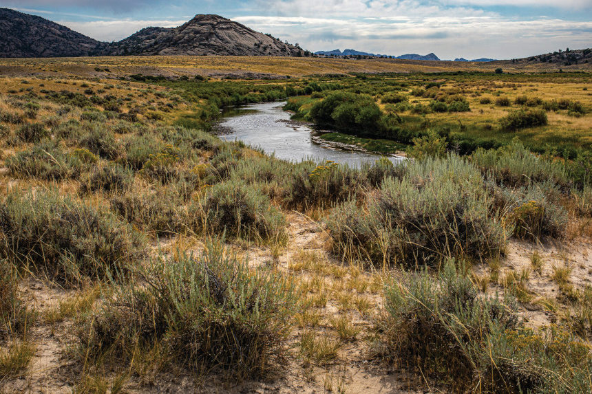
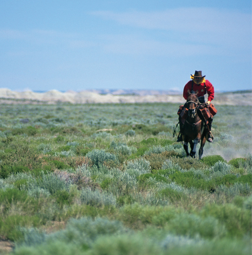
I was walking along the Sweetwater River toward the Continental Divide in southern Wyoming. The land is empty now, all sage and brown scrub stretching endlessly in every direction. One hundred seventy years ago, the view would have looked very different, filled from one horizon to the other by so many people, cattle, and conveyances that I wouldn’t have been able to see through the dust clouds scuffed up by hooves, wheels, and boots. Occasional trail markers told me that the path I was following had once been used as four distinct historic travel ways: the Mormon Pioneers Trail, the Oregon Trail, the California Trail, and the Pony Express Trail. Today, these four trails are among 19 designated by Congress to commemorate seminal movements in American history. Covering 37,000 miles in 42 states and the District of Columbia, the national historic trails encompass footpaths, roads, waterways, museums, monuments, interpretive programs, markers, battlefields, and grave sites that give us a connection between landscapes, stories, cultures — and each other.
The four trails I found myself following commemorate separate historic events, but they are contiguous for some 700 miles. No matter who you were — a Mormon trekking to Salt Lake City on faith and a prayer, a New Yorker seduced by the lure of Californian gold fields, an Appalachian family seeking a new start in Oregon’s Willamette Valley, or a Pony Express rider galloping at breakneck speed — you followed the same itinerary. First you made your way to Kearney, Nebraska, which was the last outpost where emigrants could post a letter home or stock up on supplies. From there, you followed the Platte, the North Platte, and the Sweetwater Rivers west and up to the Continental Divide. In southern Wyoming, the Continental Divide is an unimpressive plateau, and South Pass is an almost imperceptible dimple. But that is exactly the point. Before the age of automobiles and tunnels and transcontinental transit, this unremarkable passage was the only way for a wagon to get from one side of the Rocky Mountains to the other.
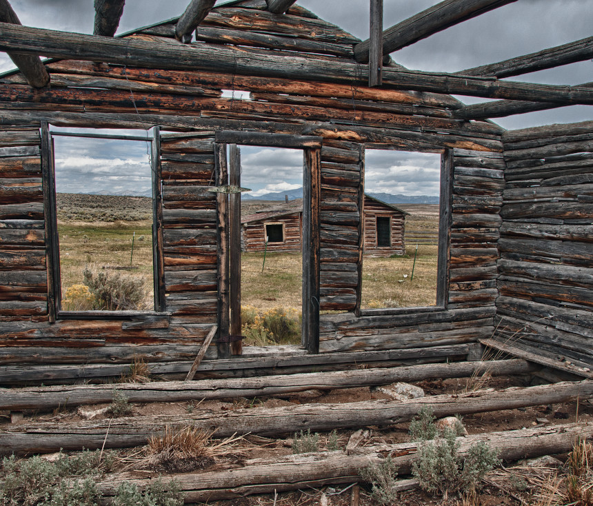
These days, the interstates and railroads go elsewhere. Most of the traffic here consists of locals in their pickup trucks, or occasional tourists, hikers, and history buffs seeking a connection with the past. Every few miles, a wreck of an old cabin, an abandoned gas rig, or a shepherd’s camp emerges from the sage-on-brown scrub. As I walked, the occasional trail marker reminded me of the people who had moved their families and their possessions across a continent on foot.
A few miles back, a monument told a more somber story. A simple headstone marked a common grave where, in October 1856, 15 members of the Willie Handcart Company had perished in an early-season storm. The group, led by a Mormon elder, James G. Willie, had set out in mid-August to walk from Florence, Nebraska, near Omaha, to the Mormon mecca of Salt Lake City 1,000 miles away. Ten days behind was a second handcart company, led by Edward Martin. Anyone who knows anything about mountain weather, the Continental Divide, Wyoming, or long-distance walking should be seeing a red flag right about now: The late departures meant that the handcart companies risked being caught in a deathtrap.
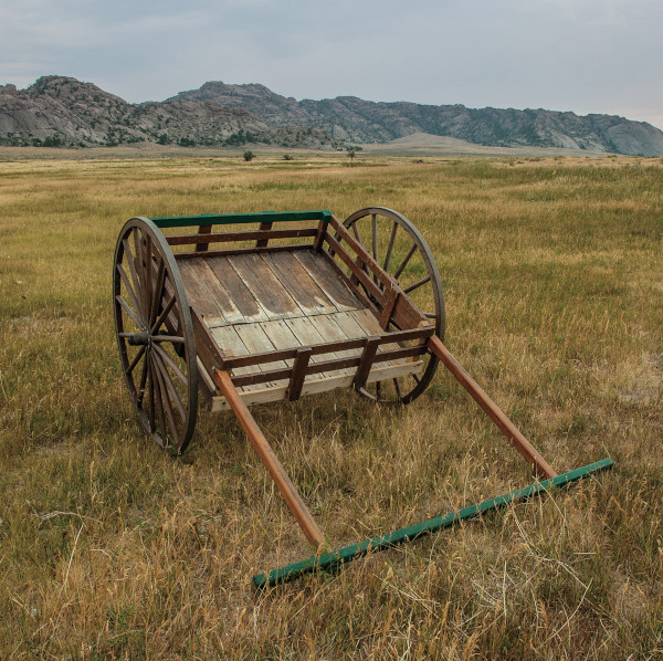
As for the “handcart” part of the company name, it refers to a sort of wheeled travois that could be pulled (or pushed) by one or more people. Imagine an oversized Costco shopping cart containing a couple hundred pounds of supplies. Imagine it as hastily made of green wood, so it lurches and sticks and veers left when you want to go right and vice versa. Now imagine pushing that thing for more than a thousand miles.
Handcarts weren’t the norm. Like their brethren on the Oregon Trail, most Mormon emigrants traveled with oxcarts. Those who could not scrape up funds for a traditional wagon were assigned to handcart companies. In the late summer of 1856, that number included two companies totaling some 1,100 Mormon converts, most of them recently arrived from England. Buoyed by faith, the pioneers started in good spirits. But three weeks into the journey, the Willie Company’s cattle — which were needed for food and for pulling the few wagons containing communal supplies — were run off, first by Native Americans, and then by thunderstorms and a buffalo stampede.
To make up for the missing cattle, each handcart took on an additional 100 pounds of supplies. Then the vicious cycle began: Overloaded handcarts broke, and fixing them took time. The remaining food had to be rationed to account for the delays — which led to more delays due to sickness and low energy. To pick up the pace, the leadership demanded that travelers lighten their loads; anything deemed unnecessary — which, unfortunately, included blankets and coats — was left on the side of the trail. The Willie Company pilgrims were nearing the Continental Divide when an early storm hit; a week behind them, the Martin Company had just made its final crossing of the North Platte River. Between the two parties, 200 people froze or died of starvation in what has been called the worst non-military disaster on the emigrant trails.
I continued walking. The sky was an innocent blue, but in the vastness of the land, I sensed the kind of tightly coiled power that could unleash Nature in her foulest temper-tantrum-wielding mood. As I walked, I pondered the difference between walking across this land as a modern-day hiker with good gear and modern maps, and walking across it yoked and chained to one of those infernal handcarts. My trip was easier, of course, but we would both have shared some of the same challenges: Now as then, one foot follows the other. Climbs sap strength; loads pull us backward. Skin blisters, muscles ache, sun burns, bugs buzz. Heat kills; so does cold. But as I considered the travails of those who traveled this same path, the weight of my backpack felt less like a burden and more like a friendly, reassuring hug.
This is the gift of the national historic trails: the sense of connection. The idea of walking in someone else’s shoes might be metaphorical, but when we actually do follow in the exact footsteps of those who came before, our connection is quite literal. “Today, more than ever, we need reminders of what binds us together,” says Barney “Scout” Mann, president of the Partnership for the National Trails System, a nonprofit organization that supports and advocates for the national trails. “The routes and stories of the National Historic Trails do exactly that: They remind us of where we once traveled and the travails we’ve overcome.”
The national historic trails are part of the National Trails System, which also includes national scenic trails such as the Appalachian and Pacific Crest trails. But the historic trails don’t conform to our usual understanding of a trail as a recreational path, usually through scenic forests, mountains, and fields. In contrast, the national historic trails are sprawling networks that take us wherever our forebears actually went. For example, the 4,900-mile Lewis and Clark National Historic Trail includes the different routes the expedition used to travel to and from the Pacific Ocean, as well as the paths they followed when they split up to explore more territory. The 5,600-mile California National Historic Trail contains the main trunk line from the Midwest to California, as well as shortcuts and side routes that evolved to travel to newly discovered gold fields or to avoid seasonal hazards such as snow, flooding, or the lack of drinking water.
On some of the historic trails, visitors have the sense of walking through landscapes untouched by time, but that is not always the case. Many original segments are buried under roads and interstates or surrounded by urban and suburban sprawl. The time-warping disconnect is sometimes startling. On the 500-year-old El Camino Real de Tierra Adentro in New Mexico, visitors can explore the route taken by the Spanish who established the first European presence in what is now the American Southwest. But when they look out from the Yost Draw, just north of Las Cruces, following a section of trail ominously called the Jornada del Muerto — the Journey of the Dead Man — they can see the jarringly juxtaposed runways and glass and steel buildings of Spaceport America, a pioneer in the field of commercial space travel.
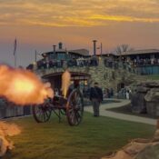
Such anomalies aside, what makes the national historic trails unique is how they combine the idea of a trail — a path through a landscape — with the opportunity to experience how and where explorers, emigrants, indigenous peoples, soldiers, refugees, protestors, and traders traveled through those landscapes. You can ride a horse in an annual Pony Express relay, trudge across the Appalachian Mountains in Revolutionary War attire, pack a wagon at an Oregon Trail interpretive center, pray at a Spanish mission in California, walk across the Edmund Pettus Bridge in honor of the 1965 Voting Rights marchers, or paddle the wild and scenic Missouri Breaks.
Or you might camp on a battlefield near the Montana-Idaho border, which is what I was doing the night I heard the ghosts.
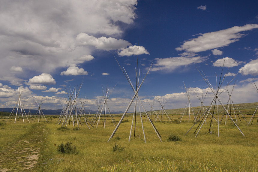
I had returned to the Rockies a year after I had hiked up to South Pass in Wyoming, this time to Montana’s Bitterroot Range, where the Lewis and Clark and the Nez Perce National Historic Trails intersect. It was early July, when the north-country sun lingers long past a hiker’s bedtime. At about 9:30, I crawled into the tent I had pitched on the edge of the Big Hole Battlefield, just down the highway from Lost Trail Pass and Chief Joseph Pass.
Lewis and Clark lost their way here (hence Lost Trail Pass) in 1805. William Clark gave an evocative description of the journey “over rocky hill Sides where our horses were in pitial danger of Slipping to Ther certain destruction & up & Down Steep hills, where Several fell, Some turned over, and others Slipped down Steep hill Sides.” The expedition almost ended right there, but after the party emerged from the ordeal, local Nez Perce provided food and helped them build canoes to continue the journey by water.
Some 70 years later, that good deed was repaid when, after a series of conflicts, a U.S. Army regiment was charged with forcing the Nez Perce onto a reservation. Chief Joseph was the leader of a contingent of Nez Perce who were fleeing, trying to find a place where they could continue their traditional lifeways. The Army caught up with them at the Big Hole. As many as 90 Nez Perce — mostly women and children — and 31 Army soldiers and volunteers died here.
A few hours after I fell asleep, I awoke to the drumming.
There’s a peculiar vulnerability when you sleep in a tent in a strange place. A fabric cocoon protects you (or so you hope) from the lingering childhood monsters that inhabit the great outdoors. But that protection is illusory. My tent mostly keeps out the rain, and it’s a pretty good barrier against insects. Beyond that, it could be broached by a butter knife.
In a tent in the woods in the night, your eyes are useless. But your ears work overtime. A mosquito sounds like a buzz saw. A mouse sounds like a grizzly bear. And the wind — the wind can sound like all the furies of hell, intent on visiting you, up close and personal.
The thumping was rhythmic, soft, like a hand on a drumhead made of leather. It started, died away, then started again. Sometimes it seemed to be coming closer, sometimes it seemed to be retreating. It sounded too rhythmic to be random. I lay stiffly, muscles tight, listening so hard I could hear the blood beating against the back of my ears.
I have written 15 books about backpacking. I have covered rain, snow, hypothermia, hyperthermia, altitude sickness, fire-making, navigating, rattlesnakes, bears, and scorpions that crawl in your boots if you leave them out in the desert. But I had never considered what to do when drumming starts in the middle of the night on a field once soaked in blood.
There wasn’t much I could do, except lie awake and ponder a story I hadn’t learned in school. Indeed, many of the stories I was learning on the national historic trails were new to me. Sometimes they were about heroism, trade, discovery, and tremendous goodness. Sometimes they were about tragedy, failure, crime, and terrible mistakes. Sometimes what they were about depended on who was doing the telling: scientists, anthropologists, historians (who often disagree with each other), indigenous storytellers (whose narratives sometimes merge with science, and other times completely contradict it), or laypeople whose legends often shape-shift in a time-traveling game of “Telephone,” where misunderstanding and miscommunication alter the stories passed from generation to generation.
At some point in the night, I fell into a troubled, jumpy sleep. When I awoke, the early solstice sun had chased the ghosts away. The drums were silent. A friend had been camped across the field, and when we reconnected, he asked me if I had heard the sage chickens in the night.
“I don’t know,” I said. “What did they sound like?”
“Sort of like this,” he said, and made the sound of a quiet, rhythmic drum.
Camping with ghosts and scurrying up the kinds of “Steep hill Sides” that almost stopped Lewis and Clark in their tracks is one way to experience the national historic trails. But there are plenty of other, more accessible entrees into these historic paths. It’s hard to get more convenient than this: in Kearney, Nebraska, the Archway Museum, which commemorates the same four trails I had followed all the way back in Wyoming, is built into a bridge that spans Interstate 80. Just 10 miles away is Fort Kearny State Historical Park (the mismatched spellings are ascribed to a mistake by the Post Office) where the four trails merged to cross the Great Plains and climb to the Continental Divide. In Kearney, the focus is on the slow, wide Platte River, which the settlers followed up to its northern tributary, more than 100 miles away.
Rivers make practical travel corridors because water — like humans — seeks the easiest way through a landscape. Animals follow the waterways, people follow the animals, roads and railways and interstates follow the earlier trails of indigenous peoples and carriage roads. So, on many of the national historic trails, we follow the paths of people who followed the water. The course of the Platte — the name means “flat” in French — is twisty and braided, the land so bereft of contour lines that sometimes, you can’t even see which way is downhill. But the travel corridor it created provided plenty of water; grasses for game, buffalo, and stock; and, for the emigrants, “easy wheeling” for the wagons.
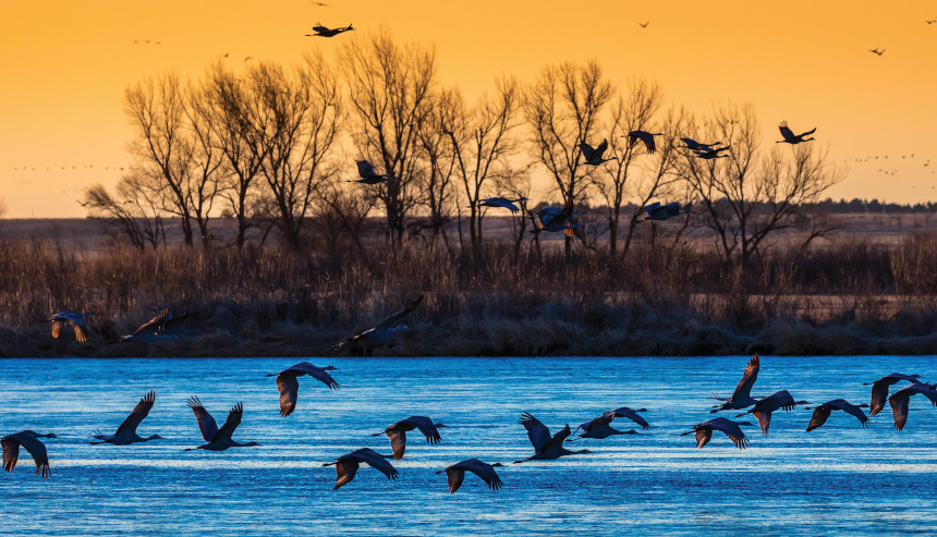
The Platte also offered a travel corridor for one of the largest and oldest wildlife migrations on the planet. In a spectacle that dates back to the last Ice Age, when the Platte River was formed, every year, about half a million sandhill cranes shelter and feed here on their cross-continental journey. Settlers may have complained that the “mile-wide, inch-deep” Platte was “too thin to plow, too thick to drink,” but the shallow braided channels make for protected roosting places: either predators don’t like getting their feet wet, or sloshing though the water is too noisy for a stealth attack. Jane Goodall, who knows a bit about such things, has described the sandhill crane migration as one of the wonders of the natural world.
On a mid-March evening, I went down to the river to see the cranes. The late winter air was cold and still. As the sky turned watermelon pink, the quiet was pierced by a squawk — and then another and another — as first a pair, then a flock, then a multitude of sandhill cranes swooped down to roost in numbers that blackened the already darkening sky. The scene was primeval: It might have looked exactly the same before humans even came to this part of the planet. Somewhere to the north, trucks were rumbling by on the interstate. Sometime in the past, the historic forces that settled and changed a continent had trudged past here, one oxcart at a time. Throughout it all, the cranes had been a witness — to recorded history, and pre-history, and to whatever came before. I thought about the stories that intersected here on the banks of this river, all of them about things in motion: cranes, buffalo, humans, oxcarts, horses, cars, trucks — and water. As night fell, the cranes quieted, and all was still except for the river, inching past, an ageless reminder of the inexorable forces of migration and movement.
Karen Berger is the author of 19 books, most recently America’s National Historic Trails. Her work has appeared in National Geographic Traveler, Backpacker, the Post, and others. For more, visit karenberger.com.
This article is featured in the March/April 2022 issue of The Saturday Evening Post. Subscribe to the magazine for more art, inspiring stories, fiction, humor, and features from our archives.
Featured image: Westward ho! Through these lands notched by Wyoming’s Sweetwater River pass 4 of 19 trials designated by Congress to commemorate seminal movements in American history. (Shutterstock)
Become a Saturday Evening Post member and enjoy unlimited access. Subscribe now