
When the term global warming first popped up on my radar in the 1980s, it didn’t sound so bad. In the northern part of the country where I was born and raised, winters were a five-month season of high heating bills, treacherous roads, cold fingers, and tons of snow to shovel. If global warming meant a break from some of that, I thought, bring it on.
Although our winters are generally getting milder and shorter, I can’t be the only one who’s less than thrilled with the severe cold snap gripping much of the country this January. Where’s global warming when you need it? I bet a lot of folks would like to get their hands on mother nature’s thermostat.
This is not to make light of global warming, a catastrophe of our making that in the near future, at least, will only worsen. It’s just that the appearance of record and near-record cold recently seems hard to reconcile with a warming world.
One of the minor issues I have with global warming, aside from the fact it doesn’t come with a remote control, is its first name. Other than astronauts and geography teachers, most people don’t think about the scale of our planet. For instance, according to a 2019 Gallup poll, fewer than six percent of American adults have a good understanding of world geography.
In our defense, most of us haven’t seen a globe since about the fifth grade. Worse yet, we’ve grown up with maps of the world that magnify land masses in higher latitudes and shrink everything near the Equator. That’s right: The maps we grew up with lied to us.
But they had to. You can’t turn a sphere into a rectangle without cheating a bit. If you don’t believe me, take a pair of scissors, a beachball, and a medium-hot iron to flatten the thing, and try to make a nice rectangular placemat with smooth edges and no bulges. I’ll check back in a week to see how you’re coming along.
If you can find an old-fashioned globe in your attic or local library, check out the longitude lines that run north-south. They’re far apart near the equator, yet converge at the poles. But when you consult a computer or wall map, the same longitude lines are now magically square like a tic-tac-toe grid.
The map of the world we used for generations is called the Mercator Projection, after the first guy to successfully iron out a globe. Teachers were grateful their classes could finally see all the countries at once without fighting over who got to spin the globe.
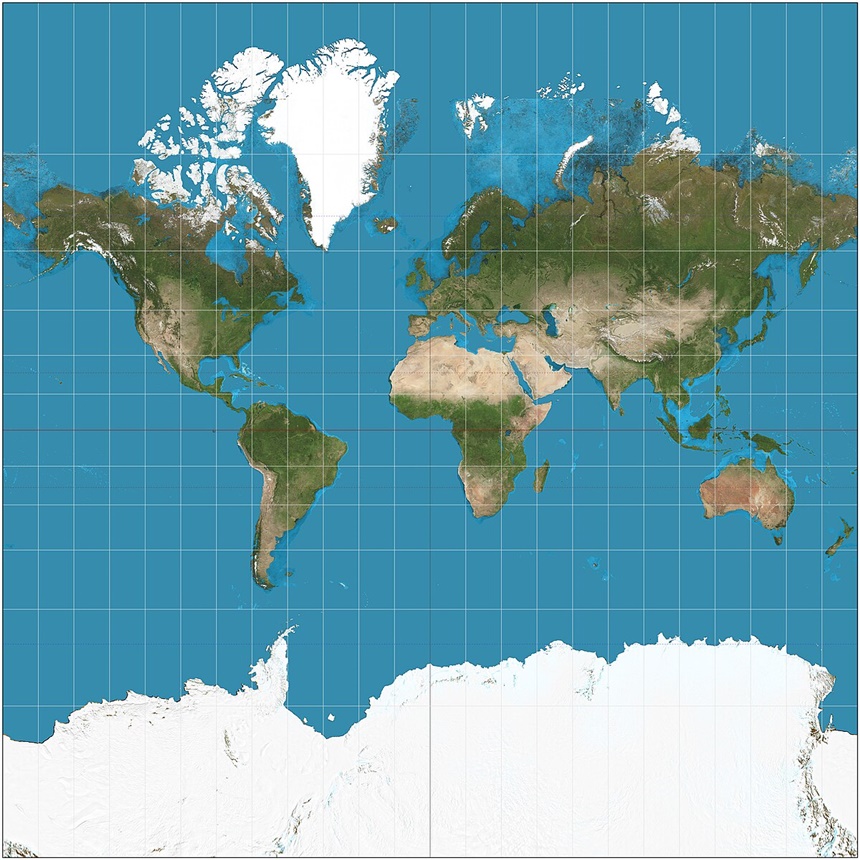
Of course, there was the issue of inaccuracy, but humanity is a busy lot, and it took a while before another model emerged. Today we have something called the Gall-Peters Projection, soon to be the world standard. It is highly accurate in terms of the relative size of land masses. It’s also a real shock the first time you see it.

Pictures used to be worth a thousand words, but the exchange rate fell off a cliff after smartphones came on the scene. Still, an image can be powerful. In the Mercator projection, The U.S. and Greenland each look roughly the same size as Africa.
On the Gall-Peters map, though, it’s clear that Africa is more than three times the size of the United States, and almost fifteen times as big as Greenland. And good luck finding the latter – it seems as if it shriveled up in the cold water and retreated into the North Pole.
Like the vast majority of us, I grew up thinking the continental U.S. took up more room than it does. It is big, of course, being the third-largest country in the world, but let’s put things in a global context: The U.S. comprises less than two percent of the surface of Planet Earth.
That’s why it’s so easy to misunderstand global warming. We’re a tiny part of the globe, and get but a wee taste of the Earth’s weather at any given time. Most of the world gets a different weather-flavor than what we experience. Right now, it’s brutally hot in Australia, South America, and southern Africa. Our planet is heating up: Temperature readings around the world are unequivocal. They’re also unbiased. Anyone who doubts thermometer readings should certainly not trust more complex scientific gadgetry like pacemakers or computers.
We’re shivering at the moment because the polar vortex, which has always been there, has paid us a visit. Usually a stable weather system over the North Pole, it has been going off the rails more often in recent decades as a result of global warming. Hopefully it will soon end its southern vacation down here, and go back home where it belongs. Let’s try to keep an accurate image in mind of our true place on the planet, and to behave accordingly.
Become a Saturday Evening Post member and enjoy unlimited access. Subscribe now


Comments
Great job on this one, Paul. I have a good many friends that now live back east after (frankly) getting the hell out of Ca., for all of the deservedly well known reasons. We talk frequently on the phone, and the pluses outweigh the minuses. Still, I just had a conversation with one today about the lingering, friggin’ freezing weather.
That very question came up of where is the global warming when we need it? And they’re not asking for too much. If the temps could even just be in the higher 20s, that would be great. Here, it’s one fire after the next with relentless winds keeping everyone nervous. At this point, maybe 30 seconds of violent shaking might be preferable; but then the aftershocks. Never mind.
Very interesting abut the polar vortex and the other links you included. No matter where we are, something has to be wrong. It’s kind of like that rare day when everything is working out perfectly, from the traffic lights being in green sync, to finding a $50 bill on the sidewalk. Rather than actually enjoy it, I’m overly conscious of how weird it is.